
Reservoir Road Public Engagement
Our concern with this proposed subdivision is the precedent it wil set for the approximately 290 hectares (736 ares) of city land that we need to protect from development on the hillsides of the Naramata Bench. Please attend the upcoming public hearing on September 12th, review the shape your city details. Send your concerns to publichearings@penticton.ca by 9:30 am September 12th. See details of reservoir road application here.
Canadian Horizons' third development application August, 2022 - say goodbye to the Greyback Elk herd

The Society for the Preservation of the Naramata Bench (SPNB) has been able to obtain the most recent Canadian Horizons’ (CH) application for the development at Spiller Rd. through a Freedom of Information Request. In turn, we had a very productive meeting with Penticton city staff about the CH application on March 10th, 2023.
In a very high-level summary, the main concerns are:
· Clearcutting of ~72 acres (to put that into perspective Vista Naramata is 34 acres)
· 1 acre lots do not coincide with OCP Rural Residential zoning of minimum of 1 hectare or 2.47 acres
· Lots are narrow, side by side like a subdivision; not conducive to a rural setting
· All of the ESA1 & 2 lands are to be sold off by CH along with their responsibility to protect them.
· Likely developer only bringing water infrastructure, this could mean shared septic for 68 mobile homes; this doesn’t work well on a hill;
· CH is trying to reduce the provincial recommended 500m buffer zone around the landfill to 300m to maximize profits and have residents sign waivers to reduce liability.
· CH’s Geotechnical consultants have limited their liability to $50,000 in light of potential litigation
· Overall concerns and contradictions between original geotechnical report from 2017 and report from 2022 (same consultant)
· Blasting of rock on lots that have slopes greater than 50% (not supposed to be allowed pursuant to hillside development in OCP on slopes >30%)
· CH Geotechnical consultant does not think terrain is conducive for disposal of groundwater
· Stormwater management plan is required and has yet to be completed by CH. They will try and do it after subdivision approval and it needs to be done before approval
· Concerns with environmental report, contradictions between original environmental report from 2020 and 2022 report; loss of Elk habitat and certain species at risk
· Removing over 11,245 trees
· CH needs to get stormwater runoff to Strutt Creek. Pipelines underground are old methodology and don’t work. How will they get the stormwater to Strutt Creek?
· Erosion concerns given the steep terrain and reduction of ground cover to the farms and homes below
· Secondary egress – will there be one? Where?
· Wild fire report – risk is “moderate”, but “catastrophic” given no fires in 10-20 years;
· Traffic studies are mostly from 2020 with less traffic due to covid and do not take into consideration the increased numbers from the many developments above and around Naramata.
We will be addressing these and other concerns from CH’s environment and geotechnical reports with our own professional consultants.
Environmental and Geotechnical Permits will be approved by City staff (Blake Laven and Michael Hodges) when they are comfortable with same – it is evolving.
The Hillside Permit will be approved (or not) by City Council. This could go before Council over the next couple of months.
The Subdivision Permit, will be signed off by the City Approving Officers (Blake Laven or Audrey Tanguay). Our lawyer has provided a letter outlining the many reasons specific to this Spiller property that give these Approving Officers the ability to reject this permit.
We have summarized 2GB of information into 2 or 3 pages of key issues in the article attached should you want more detail. We must not let what happened at Vista Naramata happen at Spiller Rd. If we allow this land to be clear-cut it will literally pave the way for development and clearcutting the hillsides all the way to Three Blind Mice.
Thank you for helping us preserve our Naramata Bench. Let's not let what happened below at Vista Naramata happen at Spiller Road (2 x the clear-cut as Vista)
For more details on this application please visit our key issues page

Results of Public engagement 1050 Spiller Road (September/2022)
80% of public against proposal by Canadian Horizons (112 Lots + carriage homes)

54% opposed to any development at 1050 Spiller Road due to environmental sensitivity and local impact to the economy
30% support some development with conditions; water brought to area, mitigate storm water concerns, address road safety; support green building, protect wildlife; density matches surrounding area and development contributes to the brand of the Naramata Bench; large rural lots
16% support development
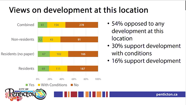
Most folks were confused about Land Use. Probably because it is so confusing!

The letters from the Penticton Indian Band, RDOS, Interior Health and our Society were against the proposed development for a multitude of reasons. Copies of the letters can be found here page 141-153 of Agenda: link to stakeholders letters

2nd Development Proposal from Canadian Horizons - Council kicks off Public Engagement May 17, 2022
Photo of Canadian Horizons land taken May, 2022
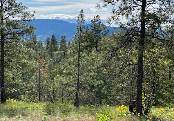

Photo of Vista Development in the hillside above Naramata to accommodate 41 lots (CH is proposing 112+ lots)
The following is an update on a new application by the developer, Canadian Horizons (CH), that will be going to public engagement any day now via Shape Your City. City Council approved taking this proposal to the public engagement process on May 17, 2022.
The new CH application has fewer homes/lots, but the same concerns that defeated the previous application remain – traffic issues, drainage concerns, environmental concerns, fire concerns, urban sprawl, tourism and economic impacts, lack of affordable housing and changing the unique character of the Naramata Bench.
The City of Penticton planning group proposed a new zoning classification called Residential Country Cluster (RCC) to appease CH and will create a dangerous precedent for future development throughout the Naramata Bench.
It would be beneficial for you to review the CH application, it starts on page 267 of this pdf link: https://www.penticton.ca/.../2022-05-17%20-%20Regular...
Key points from CH application:
-
Reducing the current Country Residential (RC) zoning from 4000 m3 (1 acre) to Country Residential Cluster (RCC) 2000 m3 (0.5 acre) and CH will require a zoning change
-
Reduce lots from 300+ to 112+ although the attached environmental report by Makonis Consulting says 134 lots (see page 16 of Makonis report).
-
CH are looking for Official Community Plan amendments to revise Rural Residential from Detached and Ground Oriented Residential in the Mobile home park area to Country Residential (RC)(and thereby "reduce density") . Mobile Residential (RSM) is a bylaw zoning designation and not part of the OCP 2045.
Between the OCP 2045 and the current zoning (1 acre), there are alarming inconsistencies. It appears the City can pick and choose what zoning they want to use. This is not what an OCP is supposed to do.
According to the City Property Records, the property is 129.081 acres or 52.237 Hectares and is defined as Rural Residential. The City Planning Department appears to support this definition as in it lays out specifically that any development “requires to be aligned with the Rural Residential Land Use designation” in its May 17, 2022 presentation to Council (see Page 268 of application link above). Adding to the contradictions, on page 293 of the Makonis report attached to the same presentation, Makonis also maps the subject area as “rural residential”.
Minimum lot sizes for Rural Residential properties are stipulated as 2.47 acres or 1 Hectare in the OCP 2045 and 1 Acre in the Zoning By-law 2017-08. The OCP 2045 was enacted in Bylaw 2019-08 and so in theory supersedes any other zoning by-laws. But, in Map 4 the OCP 2045 shows the property as Detached Residential. There is no definition of minimum lot size for Detached Residential (probably because there are numerous subcategories of this designation with differing minimum lot sizes).
Given the OCP 2045 indicates Rural Residential is 1 hectare (2.47 acres), it seems the intent of the OCP 2045 was to actually increase the lot size of Rural Residential from 1 acre to 2.47 acres. The zoning CH is attempting to put in place is going in the wrong direction, smaller lots in rural areas.
The map below shows the new CH plan. Note how many of the private lots encroach on the "environmental corridors" in green! The lot sizes will be long and narrow which means clear cutting the entire block and leaving a scar 3 X bigger than Vista in Naramata.

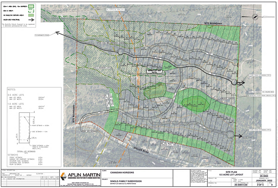
Schematic from Aplin Martin map of proposed CH development
So whats the big deal? They have reduced the number of homes from 300+ to 112+, right?
Apparently Canadian Horizons have listened to the community in their new application, right?
Wrong!
-
according to the OCP 2045, Rural Residential zoning is 2.47 acres (1 hectare); the fact this area is showing mixed density does not fit with Rural Residential and makes no sense.
-
what happened to following hillside development as set out in the OCP? There is no indication the process for hillside development is going to be followed. The analysis by CH's consultants is weak and lacking in the reality of the steep terrain.
-
what happened to the 500 m buffer next to the landfill - is 300 m adequate? Not according to Interior Health or RDOS.
-
how can the public engagement happen without proper geotechnical reports; not even a contour map? It will be TOO LATE if this should reach the subdivision stage.
-
why are there so many inconsistencies with the current 1 acre zoning by-law vs the OCP 2045 and how can there be urban zoning in a Country Residential area?
-
Look at the devastating clear cutting above Naramata - how did this happen? All this clear cutting is to accommodate 41 lots. CH is proposing 3X as much destruction. And that's only the beginning.
-
where do the roads go in the CH map? (see last page of CH application and small version at top of this page) They say "future road extension" on their map. To where? Future development toward RDOS land? It is painfully obvious approval of this development and bringing out infrastructure from the City will pave the way for future densification and clear cutting in the hillsides along our Naramata Bench.
-
do we really think the emergency escape path on the CH site plan won't become a road once adjoining sites are sold and developed? Who will build this road once CH has moved on to their next project? Who will maintain this road? It will be a very, very expensive road dumping hundreds of additional vehicles onto Naramata Road.
-
what happens to the Elk? Makonis Consulting environmental report mentions they are not sure the Elk will want to habitat the area after this construction?
-
What is the impact on First Nations rights that happens every time urban sprawl replaces wilderness habitat? The objections of the Penticton Indian Band have so far been ignored.
-
There is barely a mention in the aquatic habitats section of the environmental report of Strutt Creek, other than it is seen 300 m to the north of the subject property. Where do they think the run off will drain once the natural absorbing vegetation is replaced with a concrete subdivision? Will the farmers living below be faced with the same erosion and run off that generated millions of dollars of lawsuits between the RDOS, the farmers, the developers and the BC Government in the Outlook and Kettle Ridge Developments? Will we not learn from our mistakes of blasting rock and creating erosion and run off? See the following Tetra Engineering Report from the major problems with drainage from blasting and building into the hillside above Naramata. https://www2.gov.bc.ca/assets/gov/driving-and-transportation/reports-and-reference/reports-and-studies/okanagan/interpretation-naramata-drainage.pdf
-
Stormwater drainage design, First Nations concerns, environmental concerns, geotechnical issues, and details of future costs for maintaining and repairing infrastructure must be on the table before any public hearing, because there will be no public input at the subdivision stage.
-
what happens to the wildlife corridors once they are spread across 60 private narrow lots? What is the rationale for the long narrow lots?
-
why are Council letting this go to public engagement when one year ago the public spoke loud and clear; 14,526 people signed a petition; 42 businesses along the Naramata Bench signed a letter of non support; tractor rallies and speeches were held at city hall; many, many letters to the editor against this development; radio interviews; and on and on? The public have been engaged and they clearly said NO.
-
In 2021, Councillor Robinson said “an urban project in the middle of this rural area doesn’t belong and the current zoning is appropriate”. She suggested it was not appropriate to move forward with this project and put the area through all the concerns they have, which have been heard loud and clear (tractor rally, letters to Council; petition; newspaper articles; radio).
-
In 2021, Councillor Bloomfield spoke about the unique quality of the Naramata Bench and the agri-tourism should not be tampered with. He said the natural beauty of the area is unsurpassed, and if Council make a mistake and allow this project to go ahead, we can never go back. Bloomfield said the Naramata Bench has value to the City and brings the tourists who spend their vacation dollars here, and that this area has been zoned Country Residential for 40 years, and that was the zoning when Canadian Horizons bought the property. But why is Country Residential 2.47 acres in the OCP?
-
In 2021, Mayor Vassilaki agreed with Councillor Bloomfield, and felt this was way too big a project, there was too much potential liability with the landfill, it was a wildlife corridor, and there could be undue pressure on the city for maintaining the area, as well as potential stormwater issues.
-
In 2021, Councillor Sentes recalled how Napa Valley had the courage to retain the region, despite all the attempts to develop the land, and brave foresight has paid off 10 fold.

Photo is of the Naramata Vista Development
The concerns addressed above are significant and are in conflict with the OCP that states "we must make the most efficient use of the land infrastructure that we have available, and protect the natural environment that many of our residents value" (2045 OCP, 3-43).The key issues are summarized on our website and in our November 1, 2020 comprehensive report submitted to the City planning group and Council. Few, if any, of these concerns have been addressed as part of the latest proposal from CH.
The opportunity for one developer to cash in on a change to OCP 2045 zoning to create a densified development in this area reflects undue preference towards Canadian Horizons and puts at risk the success factors we have developed over the years, which have served Penticton well, and set us apart from other Okanagan towns.
We need to continue to drive the tone for development in our city and focus on areas that already have infrastructure that are more suitable for future development.
We need to maintain this area as the recreational and agricultural zone that defines the world class branding of the Naramata Bench and require the developer to fit their plans within the current look and feel of the area.
WHAT CAN YOU DO TO STOP THIS APPLICATION FOR URBAN DEVELOPMENT IN THE COUNTRYSIDE? URGENT ATTENTION NEEDED FOR PUBLIC ENGAGEMENT:
Send your Letters to the editor; express your concerns to:
My Naramata, Editor - Deb Linton – mynaramata@shaw.ca
Castanet Editor, Chelsie Powrie – Chelsea@castanet.net
Western News, editor@pentictonwesternnews.com
Penticton Herald, letters@pentictonherald.ca
CONTACT MAYOR AND COUNCIL
Public Engagement Manager
JoAnne.Kleb@penticton.ca
Participate in the ShapeYourCity below. You don't need to live in Penticton; all those in Naramata and along the Bench are impacted. Speak up, participate, help us stop this zoning change. Once approved, we can NEVER GO BACK.
Time to discuss 1050 Spiller Road
The City has received an application to develop 1050 Spiller Road as a single-family subdivision development. The plans submitted propose to develop 112 single family lots, varying from 0.5 acre to 1.5 acres in size. This proposal would require an amendment to the City’s Official Community Plan to change the future land use designations on the subject property to be primarily ‘Rural Residential’ and allow for 0.5 acre lot sizes. Before the application is considered by City Council, the City would like to gather feedback from the community about changing the ‘future land use’ of this property. Residents are invited to review the information and share their feedback before July 3rd through shapeyourcitypenticton.ca.
Citizens interested in learning more and discussing the proposal with staff and other participants have four events to choose from:
-
Attend an Online Info Session on June 9 or 23 between 6:30 pm and 8 pm. Go to shapeyourcitypenticton.ca to sign up and receive the link.
-
Drop by an In-person Open House between 10 am and 12 pm on June 18 outside at Uplands Elementary or June 25 at the Penticton Seniors’ Drop-in Centre.

Photo of Vista Development above Naramata; irony of the Elk and Moose signs, not much respect here
Penticton Herald Poll


February 16th, 2021, Penticton Council deny Canadian Horizons 1st application
On February 16, 2021 Penticton Council and Mayor voted 6-0 in a unanimous decision to deny Canadian Horizons' rezoning application at 1050 spiller road. The community will get to decide the fate of future applications. We are grateful to the communities support including the letter from 42 businesses along the Naramata Bench that supported the initiative to stop the rezoning. Special thanks to all Penticton Council and Mayor from the farmers, wineries, businesses, and residents of the Naramata Bench.
Canadian Horizons 1st subdivision application being introduced to Council, Tuesday, February 16th, 2021

N

S
Canadian Horizons first application for 350 homes September, 2020
Canadian Horizons' (CH) is proposing to rezone 126.4 acres of hillside wilderness above the Naramata Bench from Country Residential zoning (east circle marked in yellow) into a dense urban-style subdivision they call "Vinterra" and build 320+ homes + carriage houses. The City Planning Department is currently in the process of reviewing the high density land use plan and technical reports submitted by Canadian Horizons' and will be bringing recommendations to Council on February 16th, 2021. This will be a closed meeting and not open for public input but can be viewed online. Then we will find out more about the public engagement process that has already been kicked off. Given the requirement to rezone the land, public input is required by the City zoning Bylaws. The subject property, 1050 Spiller Road, is immediately north of the the Campbell Mountain Landfill.
1050 Spiller is approximately 126 acres of which 15 acres is zoned Mobile Home Park Housing and 111 acres is RC Country Residential. Country Residential zoning in this area calls for a minimum lot size of 1 acre. Country Residential zoning should be revised pursuant to the 2045 OCP that has Rural Residential zoned for 2.47 acres (1 hectare) minimum lot size. This would align the OCP with the country character of the area and provide larger lots sizes conducive to rural living and prevent clear cutting the area.
Canadian Horizons is planning to build a road from the 33.8 acres at 880 Naramata Road up the mountain. Vehicles from the development will emerge onto Naramata Road close to 880 Naramata Road. Ironically, the locals call this spot along Naramata Road "accident corner". It is in the vicinity of Red Rooster and Little Engine Wineries, where you have likely seen the piles of dirt, gravel and weeds for the last 2 years.
If the Canadian Horizons' rezoning is successful, there are two other large parcels of land for sale (marked in red and goes further North) that could also be developed, with an additional 90 acres and 72 acres respectively. This acreage is on the hillside between the Canadian Horizons land and Three Blind Mice.
Allowing the Naramata Bench to be developed beyond the current agricultural and rural density would forever change the look and feel of the area. It would take away from the destination as a sought after recreational area, affect wildlife, and negatively impact the agri-tourism business and brand that has taken years to develop.
There are numerous areas in Penticton for high density housing projects and other housing opportunities that wouldn't encroach on agricultural areas or require this type of rezoning.
We are in favour of smart and sustainable development in alignment with the guiding principles of the Penticton Official Community Plan (OCP). Let's all work together as a community to alter the path of the developer and Preserve the Naramata Bench.